
Weather in Khon Kaen, Thailand
Average Weather
Information source: http://weatherspark.com/averages/33984/Khon-Kaen-Thailand
This report describes the typical weather at the Khon Kaen Airport (Khon Kaen, Thailand) weather station over the course of an average year. It is based on the historical records from 2005 to 2012. Earlier records are either unavailable or unreliable. Khon Kaen has a tropical savanna climate with dry winters. The area within 40 km of this station is covered by croplands (95%) and lakes and rivers (3%).
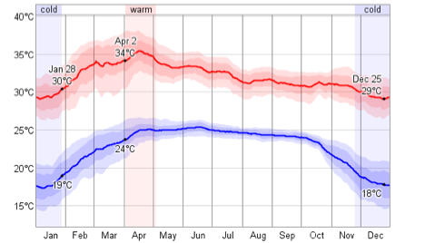
Daily High and Low Temperature. The daily average low (blue) and high (red) temperature with percentile bands (inner band from 25th to 75th percentile, outer band from 10th to 90th percentile).
Information source: http://weatherspark.com/averages/33984/Khon-Kaen-Thailand
This report describes the typical weather at the Khon Kaen Airport (Khon Kaen, Thailand) weather station over the course of an average year. It is based on the historical records from 2005 to 2012. Earlier records are either unavailable or unreliable. Khon Kaen has a tropical savanna climate with dry winters. The area within 40 km of this station is covered by croplands (95%) and lakes and rivers (3%).
Daily High and Low Temperature. The daily average low (blue) and high (red) temperature with percentile bands (inner band from 25th to 75th percentile, outer band from 10th to 90th percentile).
Historical Weather For The Last Twelve Months of 2012
Information source: http://weatherspark.com/history/33984/2013/Khon-Kaen-Thailand
This report describes the historical weather record at the Khon Kaen Airport (Khon Kaen, Thailand) during the last 12 months. This station has records back to January 1949. Khon Kaen has a tropical savanna climate with dry winters. The area within 40 km of this station is covered by croplands (95%) and lakes and rivers (3%).
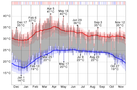
The coldest day of the last 12 months was January 1, with a low temperature of 14°C. For reference, on that day the average low temperature is 18°C and the low temperature drops below 15°C only one day in ten. The coldest month of the last 12 months was January with an average daily low temperature of 18°C. Relative to the average, the coldest day was May 17. The low temperature that day was 20°C, compared to the average of 25°C, a difference of 5°C. In relative terms the coldest month was October, with an average low temperature of 23°C, compared to an typical value of 23°C. The longest cold spell was from July 7 to July 16, constituting 10 consecutive days with cooler than average low temperatures. The month of September had the largest fraction of cooler than average days with 73% days with lower than average low temperatures.
Information source: http://weatherspark.com/history/33984/2013/Khon-Kaen-Thailand
This report describes the historical weather record at the Khon Kaen Airport (Khon Kaen, Thailand) during the last 12 months. This station has records back to January 1949. Khon Kaen has a tropical savanna climate with dry winters. The area within 40 km of this station is covered by croplands (95%) and lakes and rivers (3%).
The coldest day of the last 12 months was January 1, with a low temperature of 14°C. For reference, on that day the average low temperature is 18°C and the low temperature drops below 15°C only one day in ten. The coldest month of the last 12 months was January with an average daily low temperature of 18°C. Relative to the average, the coldest day was May 17. The low temperature that day was 20°C, compared to the average of 25°C, a difference of 5°C. In relative terms the coldest month was October, with an average low temperature of 23°C, compared to an typical value of 23°C. The longest cold spell was from July 7 to July 16, constituting 10 consecutive days with cooler than average low temperatures. The month of September had the largest fraction of cooler than average days with 73% days with lower than average low temperatures.
Temperature. The daily low (blue) and high (red) temperature during the last 12 months with the area between them shaded gray and superimposed over the corresponding averages (thick lines), and with percentile bands (inner band from 25th to 75th percentile, outer band from 10th to 90th percentile). The bar at the top of the graph is red where both the daily high and low are above average, blue where they are both below average, and white otherwise.
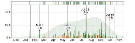
Precipitation. The full year of hourly present weather reports with the days of the year on the horizontal and the hours of the day on the vertical. The color-coded categories are thunderstorms (orange); heavy, moderate, and light snow (dark to light blue); heavy, moderate, and light rain (dark to light green); drizzle (lightest green); freezing rain and sleet (light and dark cyan); snow grains (lightest blue); hail (red); fog (gray); and haze (brownish gray).
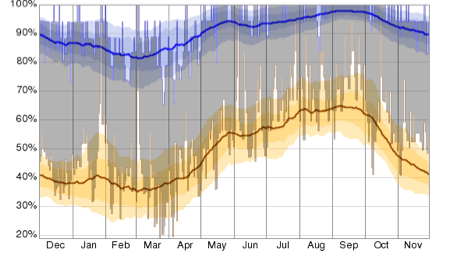
Humidity. The daily low (brown) and high (blue) relative humidity during the last 12 months with the area between them shaded gray and superimposed over the corresponding averages (thick lines), and with percentile bands (inner band from 25th to 75th percentile, outer band from 10th to 90th percentile).
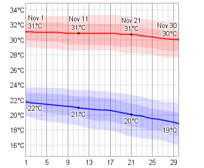
Daily High and Low Temperature in November. The daily average low (blue) and high (red) temperature with percentile bands (inner band from 25th to 75th percentile, outer band from 10th to 90th percentile).